Metop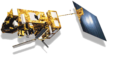
The era of the analogue APT weather satellite entered its final phase with the successful launch of NOAA N-prime, the last of its line, on February 6, 2008. APT transmissions could well last a further decade or more as long as the satellite remains in good health.
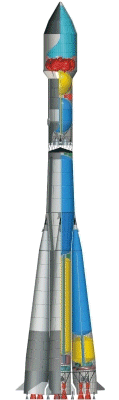
The first of the replacement digital polar orbiting satellites, EUMETSAT's Metop-A, was safely launched aboard a Soyuz-2 launcher on October 19, 2006 and is performing well. Metop B was launched in September 2012. Metop C is currently sheduled for launch in 2016.
Metop is the space segment of the EUMETSAT Polar System (EPS).
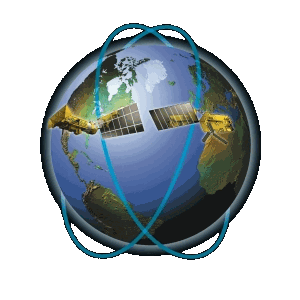
Metop flies at a nominal altitude of 820 kilometres, in a 5-day repeat orbit, making its descending equator crossing around 09:30 hours local time. The three satellites of the Metop series should span an operational period of at least 14 years, with an expected life time of 5 years each.
Data is continuously recorded on board Metop then dumped to acquisition stations once per orbit for further processing. Products are disseminated to users by EUMETSAT's EUMETCast system. This allows a global coverage which is completed every 1 to 3 days depending on each particular instrument's swath.
Direct reception of data is possible, via high-rate AHRPT (Advanced High Resolution Picture Transmission) at a data rate of 3.5 Mbit/ sec (recommended 2.4 metre tracking antenna).
It had originally been planned to disseminate low-rate LRPT (Low Resolution Picture Transmission) imagery on 137.1 MHz but, due to on-board equipment anomalies, dissemination had to be abandoned.
As it has proved unfeasible to rectify these problems for the future Metops B and C, it has been decided to abandon the Metop LRPT operational service completely.
Data Products
| MetOp AVHRR The Advanced Very High Resolution Radiometer, provides 6-channel (though only 5 are disseminated at any one time) VIS and IR imagery of clouds , the ocean and land surfaces. (In the first box option - global coverage) MetOp AMSU_A. MetOp ASCAT MetOp GRAS |
MetOp GOME The Global Ozone Monitoring Experiment profiles stratospheric ozone and other atmospheric constituents. MetOp HIRS MetOp IASI The Infrared Atmospheric Sounding Interferometer provides enhanced atmospheric sounding of temperature, humidity and trace gases, including ozone. MetOp MHS |
Example Metop AVHRR Images
You can read here about some of the further products added to the EPS system.
Data Access
Access to the AVHRR data from Metop by direct reception, as from the current NOAA satellites, will be free.
EUMETSAT Operations Bulletin No 11 states
"Under nominal operations, these data will be unencrypted and available to users without licence and without charge."
It is also understood that, for amateur and educational users, the data disseminated via the EUMETCast service will also be available without charge.
EUMETCast Reception
To receive the data from EUMETCast, you will of course have to be within the footprint of either the Eurobird 9 (Europe) or the Atlantic Bird 3 (Africa) satellite. You should be able to use your existing EUMETCast receiver, although, because of the increased data rates, you may have to install a parallel system just for Metop data unless you have a particularly high-specification PC. (And of course, if you don't already have a EUMETCast setup, there will be a low-cost antenna, PC card, and software available for purchase from the GEO Shop).
The World Meteorological Organisation lists data transmission standards for both current and future weather satellites.
You can obtain further general reading about Metop from the following links: